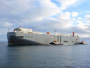
EASTERN HIGHWAY
Vehicles Carrier, IMO 9325764
Buque llamado EASTERN HIGHWAY, registrado con el número IMO 9325764, MMSI 538007611 es Vehicles Carrier. Actualmente navegando bajo bandera Marshall Islands. Se construyó en 2006.

Datos AIS
Yokohama, Japan
ETA: Apr 26, 21:00
(in 3 days)
| Predicted ETA | |
| Distance / Time | |
| Rumbo / Velocidad | |
| Calado actual | 6.9 m |
| Navigation Status | - |
| Position received |
12 days ago
|
| IMO / MMSI | 9325764 / 538007611 |
| Señal de llamada | V7WS3 |
| Bandera | Marshall Islands |
| Eslora / Manga | 188 / 28 m |
Panama Canal Anch. Pacific, Panama
ATD: Apr 6, 19:29 UTC (17 days ago)
Posición del mapa & Weather
Ultimo puerto de recalada
Vessel Utilization
Datos maestros
| Numero IMO | 9325764 |
| Nombre del buque | EASTERN HIGHWAY |
| Tipo de barco | Vehicles Carrier |
| Bandera | Marshall Islands |
| Puerto de origen | |
| GT | 39422 |
| DWT (t) | 12991 |
| Eslora (m) | 188 |
| Manga (m) | 28 |
| Calado (m) | |
| Año de construccion | 2006 |
| Constructor | |
| Lugar de construccion | |
| Astillero |
| TEU | - |
| Crudo (bbl) | - |
| Gas (m3) | - |
| Grano | - |
| Fardo | - |
| Classification Society | |
| Armador registrado | |
| Owner Address | |
| Owner Website | - |
| Owner Email | - |
| Gerente | |
| Manager Address | |
| Manager Website | |
| Manager Email |
Historia
| Nombre del buque | Armador registrado | Año |
|---|---|---|
| EASTERN HIGHWAY | 2006 |
Similar vessels
| Buque | Construido | GT | DWT | Tamaño (m) |
|---|---|---|---|---|
 WESTERN HIGHWAY Vehicles Carrier |
2007 | 39422 | 12980 | 188 / 28 |
 NORTHERN HIGHWAY Vehicles Carrier |
2009 | 39422 | 12856 | 188 / 28 |
 VIKING SEA Vehicles Carrier |
2012 | 39454 | 12550 | 167 / 28 |
 VIKING OCEAN Vehicles Carrier |
2012 | 39454 | 12550 | 167 / 28 |
 VIKING EMERALD Vehicles Carrier |
2012 | 39454 | 12459 | 167 / 28 |
 VIKING DIAMOND Vehicles Carrier |
2011 | 39362 | 12572 | 167 / 28 |
 VIKING CORAL Vehicles Carrier |
2011 | 39362 | 12588 | 167 / 28 |
 VIKING AMBER Vehicles Carrier |
2010 | 39362 | 12471 | 167 / 28 |
 SILVER SUN Vehicles Carrier |
1988 | 39187 | 9772 | 183 / 30 |
 SOUTHERN HIGHWAY Vehicles Carrier |
2008 | 39065 | 12892 | 188 / 28 |
Descargo
EASTERN HIGHWAY current position and history of port calls are received by AIS. Technical specifications, tonnages and management details are derived from VesselFinder database. The data is for informational purposes only and VesselFinder is not responsible for the accuracy and reliability of EASTERN HIGHWAY data.