University of Hawaii Mānoa researchers have equipped 10 Matson and Maersk Line ships with real-time surveying GPS systems and satellite communications to create a network of low-cost tsunami sensors.
Accurate and rapid detection and assessment of tsunamis in the open ocean is critical for predicting how they will impact distant coastlines, enabling appropriate mitigation efforts.
The researchers, funded by NOAA, are partnering with Matson, Maersk Line and the World Ocean Council to use commercial ships operating in the North Pacific to construct a network of low-cost tsunami sensors to augment existing detection systems.
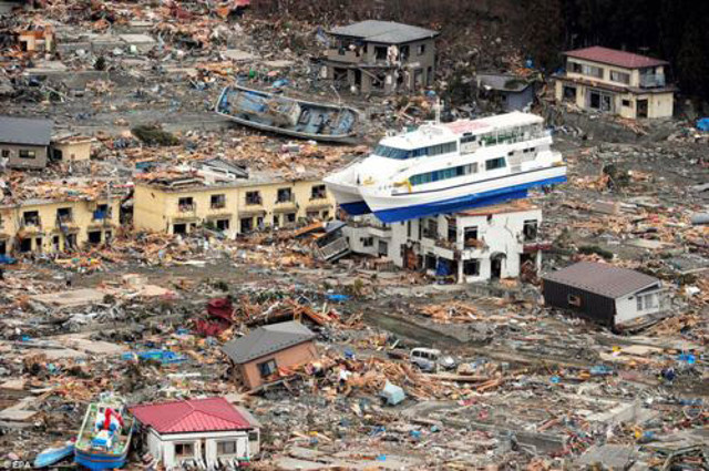
Japan's coastline after the tsunami wave in March 2011 / Image: EPA
The newly built pilot network of GPS-equipped ships enables each vessel to act as an open-ocean tide gauge. Data from these new tsunami sensors are streamed, via satellite, to a land-based data center where they are processed and analyzed for tsunami signals.
“Matson was an obvious partner for this project due to their long history in Hawaii and shared interest in community safety and coastal hazards,” said James Foster, associate researcher and lead investigator for the project.
“The unexpectedly huge 2011 Tohoku, Japan earthquake and the unanticipated type of fault slip which caused the 2012 event at Queen Charlotte Islands, Canada highlighted weaknesses in our understanding of earthquake and tsunami hazards and emphasized the need for more densely-spaced observing capabilities,” said Foster.
Despite the advances in tsunami monitoring and modeling technology over the last decade, there are too few observations of tsunamis to provide sufficiently accurate predictions required for hazard response agencies to be able to make the best possible response to tsunami events.
In particular, there are very few sensors in the deep ocean between the tsunami source and the distant coastlines that might be threatened. The sensors that do exist are expensive to build and maintain, so only a limited number are deployed. Gaps in the coverage of the network, as well as routine outages of instruments, limit the ability of the current detection system to accurately assess the hazard posed by each event.
This new approach offers a cost-effective way of acquiring many more observations to augment the current detection networks.
By chance, in 2010, the researchers discovered that the ship-based GPS on board the University of Hawaii research vessel Kilo Moana were able to detect and measure the properties of tsunamis in the open ocean, thus paving the way for the current project.
The researchers are now working with the NOAA Tsunami Warning Centers to ensure that the network provides the most useful data possible, and they will be working with their industry collaborators to develop a new version of the shipboard package that can be deployed on a much greater number of ships.
Source: maritime-executive.com